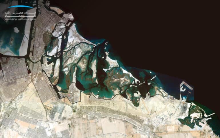

The Mohammed Bin Rashid Space Centre (MBRSC) today announced the completion of an updated map of the Abu Dhabi and Dubai using the UAE’s first high-resolution satellite image “Mosaic”, captured by KhalifaSat. The system captures a matrix of individual digital images to create a single high-resolution picture of the UAE’s terrain.
This imaging system by MBRSC will provide a comprehensive view of the UAE’s topography, using remote sensing systems, image processing, geographic information systems and artificial intelligence.

The system is part of the Mohammed Bin Rashid Space Centre’s efforts to support federal and local government entities, research and academic institutions as well as the private sector to take advantage of this type of technology that plays an important role in understanding the geography, topography and environmental impacts of large areas in the UAE more accurately.
In view of the MBRSC’s efforts to spread knowledge, expand the use of space technologies owned by them and extend cooperation frameworks to all entities, “Mosaic” will be provided to all government and non-governmental entities free of charge for the purpose of benefiting the agencies and enhancing their role in the UAE society.
The Mohammed Bin Rashid Space Centre collects images of a specific geographic area through the KhalifaSat at specific intervals ranging from days or months. These images are then combined to form one single comprehensive image with a high visual resolution of up to 0.7 meters, in TIFF format, well-known for storing raster graphics images.
“The Mohammed Bin Rashid Space Centre seeks to contribute effectively to the community through projects that support the development sectors in the UAE. Over the past few years, MBRSC has established itself as an efficient and leading space centre for the Middle East region, weighed in by the impact of its projects and technologies in non-space sectors as well. The launch of KhalifaSat’s first satellite image “Mosaic” is of strategic importance to support the infrastructure of all vital sectors in the UAE and promote strategic decisions by key stakeholders operating in the country.” said His Excellency Yousuf Hamad AlShaibani, Director General, MBRSC.
MBRSC is also keen to hold regular meetings with government departments to find out the nature of their activities and provide integrated solutions to meet their needs and provide them with the required satellite images. The services are also being extended to entities in the private sector. The Centre will also partner with local statistics authorities as the outcomes offered by KhalifaSat play a crucial role in promoting the exchange of expertise in addition to providing data to different sectors in order to assist them in drafting reports for infrastructure projects.
“The “Mosaic” imaging system at the Mohammed Bin Rashid Space Centre goes through systematic stages of image extraction. Firstly, individual images scattered over an area are taken by the satellite during a given period. The system then geo-assigns these images using a coordinate reference system to ensure the highest possible resolution. The image correction phase is followed by enhancing contrast and various corrections to make sure that all images are free of distortions. Finally, the colours of the satellite images are matched and blended, followed by the testing of the outcome by the relevant team, and ensuring its correctness before finally releasing it.” explained Ammar Saif AlMuhairi, Head of Image Processing Section, MBRSC.
The Mohammed Bin Rashid Space Centre owns remote sensing satellites, like the DubaiSat 1 and 2 satellites and its successor KhalifaSat. These satellites have helped produce several scientific reports and studies that are dedicated to observing and monitoring the Earth, and also provides satellite images.
